
Rebublic of Kazakhstan
Akmola region, Kokshetau sity
Kokshe Academy
THE TASKESKEN’S PETROGLIPHS
Reviewers:
doctor of historical sciences, Professor Victor Feodorovich Zaibert, director of scientific and archaeological expeditions "Botai".doctor of historical sciences, professor Samashev Zeynolla, Director of the Institute of Archaeology and Ethnology im.Ch.Valihanova Astana
Kokshetau, 2011
Project author: Kursabaev Muhamedrahim Kadyrbaevich, Ph.D., Vice Rector of the Academy of Science "Kokshe"
Adress: 020000. Repblic of Kazakhstan, Koksetau city,Esenberlin street 38,Kokshe Academy, tel/fax: +7-7162- 327018,mob: +7-701-655-72-61, kursabaev_mr@mail.ru
BRIEF DESCRIPTION OF THE PROJECT
Petroglyph (rock drawings of ancient people in the Bronze Age) - the so-called cultural and mythological monument "taskesken peoples", a unique architectural monument of human civilization, the representatives who had lived in the hole at the oasis "Karakol-Urdzhar" in Eastern Kazakhstan (ASD, Urzhar district, village Taskesken).
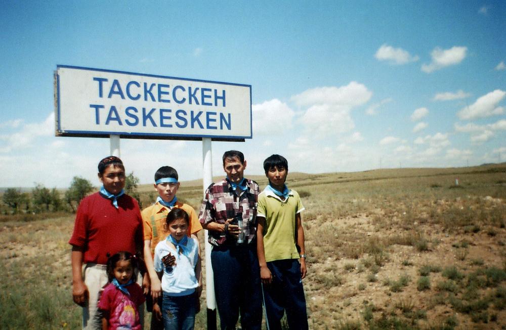
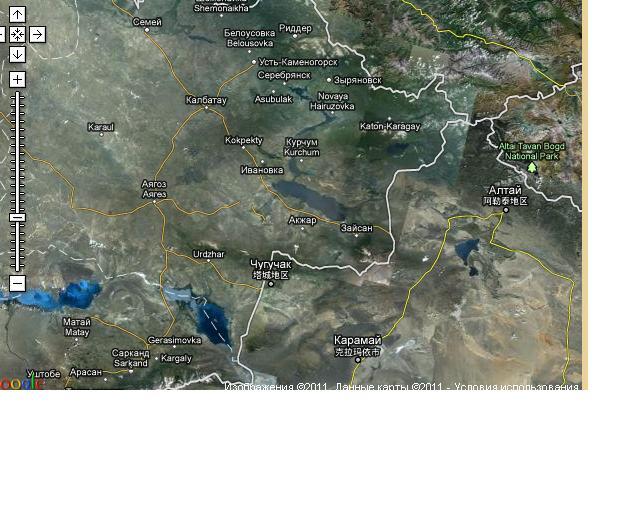
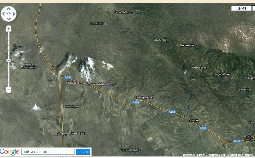
Aul Taskesken located at the intersection of the international highway of Astana-Novosibirsk-Urumqi (Kazakhstan, Russian Federation, China).
Region's climate is continental. In summer the temperature reaches up to +25-30 C in winter goes down to -28-32 C. Population Taskesken about 5000 inhabitants. Poorly developed infrastructure. The village has a hospital, schools, cultural, leisure and sports facilities and creative. Developed argotehnicheskaya (Agriculture), livestock, vegetable and melon production activity spheres of public service and food. Underdeveloped tursticheskaya area. There is a hotel, pharmacy, camping, paniony and catering (canteen, cafe). Valid market, shops.
Nature Taskesken unique. Aul at the foot of the mountains Tarbagatai. Ridge Tarbagatai mountain systems extends from north to south. Taskesken site has a small height (Ak-Shaul hill 256 m, 178 m Shaulder, Biyk Kyzyl 125 m). From the north-eastern ridge originates river Karakol (184 km hydrospheric REC 1940 sq km) which flows along the central part of the village. River deepest, clear and drinkable.
Around the river are common forest shrubs. Mountain-shrub portion of the river is rich in flora and fauna. Downstream river flows through the semi-saline relfy feather. The floodplain of the river and the dam is used for agronomic purposes. The river is rich in fish fauna and avifauna. There are carp and gudgeon marinka. Oasis top (mountain area) represents a unique ecosystem of the river. In the mountains there are bear, lynx, beaver, fox, wolf of birds eagle, golden eagle, vulture, and wild ducks.
Stone images of ancient people are from 3 km to the tract of Ush-Bulak Taskesken. Ush -Bulak is suitable for grazing. There are several objects of the crop use (a few houses, construction of the winter for the cattle-kashar, temporary shelters for shepherds, herdsmen). Ush -bulak along the east-north flowing river dry.
Tract Ush-Bulak is between the small hills. The soil and vegetation around the volcano is a unique and beautiful natural environment. Along the river (no name) covered by a dense shrub. There are some varieties of trees and shrubs. In some areas there are caves of the mountain scenery of small size, but are suitable for temporary housing.
Place of stay and location of the ancient artists in the Ush-Bulak was associated with the development of pastoral farming in the region. The organization of economic activity was largely dependent on the events and the annual cycles of nature and climatic conditions. It is known that ancient herders in the summer time, cattle driven off the foot of the mountain ranges (Dzhaylyau) and zmnie time polupustnnye or wind steppe zone (kystau) for the snow falls in intense fluxes of wind circulation.
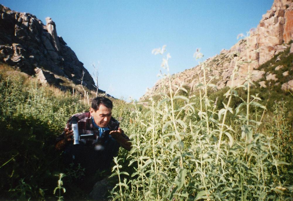
During the cruise, we visited the summer haven of modern cattle-herders. They warmly welcomed us and gave thee drink koumiss and tasty meat treated vysokokalloriynym horse.
RESEARCH IN PETROGLYPHS
According to scientists, researchers first stone artists in Kazakhstan (not just Taskesken, but other places as Tamgaly Karatau Ulytau, Arpauzen, Eshki-Olmes, etc.) have appeared about four thousand years ago. This is evidenced by the archaeological description in national publications. [4.12].
| Tamgaly petroglyphs in Kazakstan http://en.wikipedia.org/wiki/Petroglyph#Kazakhstan Николай Кузнецов www.Николай-Кузнецов.рф Алтын Емель. Петроглифы |
All archaeological sites are listed in Eastern Kazakhstan Archaeological map of Kazakhstan. In the great merit of the outstanding scientist Prof. Pedagogy, K. Baypakova, K. Akisheva, J. Taymagambetova, VF Seibert, Z. Samashev, Maryasheva AN Analysis and interpretation of research materials related to the petroglyphs found that "taskeskenskie petroglyphs" were not included in the list of the objects.
In the archaeological map of Kazakhstan is also no data are available on the petroglyphs of the tract "Altyn-Emel" (Almaty region, Panfilov district, g.Zharkent).
The stone figures are found not only in Kazakhstan but also outside it. On the bases of the Internet resources we have found that many petroglyphs wonderfully spread throughout the world. These include Outside Parras, Coahuila, Mexico, White Sea petroglyphs in Russia (http://nordictravel.ru/rus/petroglyphs.html), «The newspaper's Stone" (Utah, USA) in America.
Outside Parras, Coahuila, Mexico http://en.wikipedia.org/wiki и Таскескенский петроглиф
The great Kazakh scholar, educator Chiocan Valikhanov which made the trip to China (out route) decided to visit the mausoleum "Goats Korpesh and Bayan Sulu" on the road followed the route Novosibirsk-Urdzhar-Chuguchak. Along the way he carefully rasprashival population of the geographical location of the region, the demographic situation as well as folklore and etnogorafii. According to A. Margulan he was aware of the stone figures (this raskazyvali hunters), the medieval town of parking, "Naiman-twist" the golden path around tsarskie elephant Tarbagatai Mountains (pathways are the founders of Kazakh batyrs Kabanbai and Ahtamberdy bard), and more. Ride Ch.Valihanov confirms the historical place of the "shock tasy" (stone bench Chiocan) which is located on a hill near Zhai-tobe s.Makanchi (70 km from Taskesken). In the long-term archaeological Academician Margulan was scheduled archaeological expedition oasis in "Karakol-Urdzhar."
About Taskesken stone figures were devoted to local history materials Kozhaeva A., O. Turgazin, J. and G. Shakarimov Kulakhmetov. In spite of the collected material empiritivny this territory does not become an object of scientific and archaeological research. 2006 Taskesken petroglyphs were obetom attention initiative groups consisting of T. Musanov, MK Kydyrbayuly, F. Muhtarkyzy, A. Muhamedrahimuly and others who made the private tourism and local research expedition. The result was a collected material of great interest.
Taskesken region was selected for the stock-artists as a place for summer pasture and the other as the best relief for the realization of creative and visual arts.
Research data on the coastal waters of the Irtysh River is home to the ancient representatives of the Stone Age. In the works of S. Chernikov (archaeological data Irtysh, stone ware, pischera, parking) [7.201] and J. Taymagambetov (parking Kozybai, the settlement near the river Kalgutty, artifacts of the Stone Age) [24,26-27] as well as a fundamental works . Shitnikov B. [25.261] and VF Seibert [13.128] on the ancient migrations of pastoralists in Kazakhstan provides a basis that Taskesken has attracted much attention of the ancient herdsmen. The favorable climate, rich flora and fauna was the decisive factor for the intensive development of these territories mainly to expand the geography of pastoral farming.
Based on the above study should lead to the conclusion that the stone caves inhabited by representatives of the Stone Age (ridges Kalba, Saur-Tarbagatai) and tributaries of the Irtysh (Bukhtarma, Kurchum, Both Ulba ball) which provided favorable soil and vegetation cover (mountain-steppe oasis ) for economic activities of ancient people (parking Koytas, Kanai, Zhelezinka, Ablaketka, nurmambet, Zevakino, Kokdombak other Andronovo settlement) and their extension to the side Taskesken.
|
LOCATION TASKESKENSKIH PETROGLYPHS
|
The ancient artists inhabited these punishing about 4 thousand years ago. Surprisingly nature is preserved pervoizdannom form. A small river which originates not from the glacial peaks Tarbagatai the contrary from the spring. Water in a spring clear and drinkable. Around the river formed many species of shrubs. They grow wild cherry (moyyl), apples, a lot of shrub abundance of wild fruits like raspberries, berries, currants, etc.
Congenial atmosphere creates an unusual comfort for travelers who crossed the road in an oasis of "Karakol-Urdzhar."
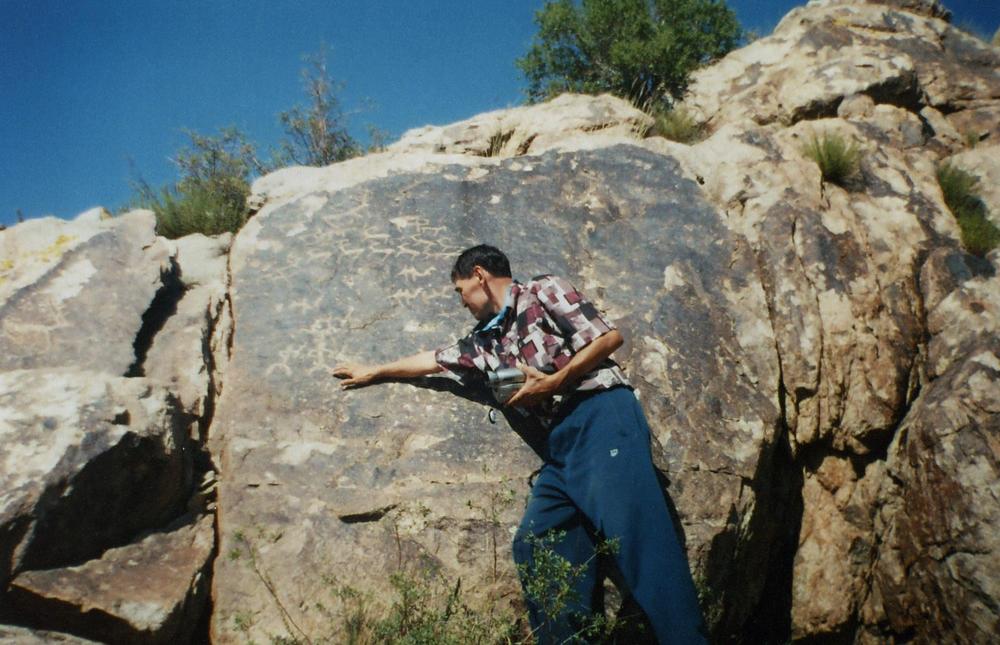
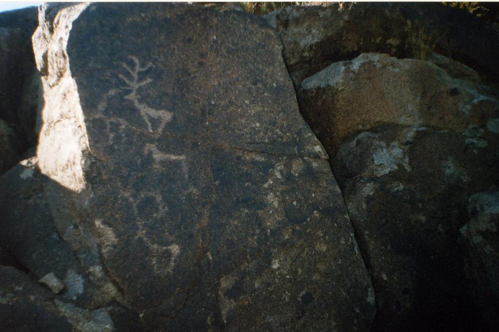
General view of the location of the petroglyphs Taskesken
Artists living in these areas temporarily. It is evident that they were here mainly in the warm seasons. Lush mountain-grove and the covering optimal land cover area, confirms the maximum precipitation (from 350 to 88 mm per year) which flow into the oasis.
By hypothesis, for "taskesken people" these places have not only an accomplishment for skotovedchesko and economic activity, on the other hand had a cultural and mythological significance. By writing the stone figures that they believed in svehestestvennye force. The drawings were mostly zoomorphic association decision. Of them had a special place camel and deer horns 7.
Deep poklenenie to the mighty power of the animal world, as the beginning of the human world view protototemisticheskoe artists wanted to convey thoughts ie the tradition of his generation. From this statement should not conclude that the ancient people in place for various reasons (natural hazards, tectonic faults, earthquakes, and pozharoa droughts, floods) eating meat and dressed procession of animals, considered these as a gift of supernatural forces.
These first-religizno mythological ideas were not only religious-traditions of ancient totemic "taskeskenovtsev", in turn, enabled the emergence of an empirical notion of philosophical and religious ideas about the world as an expression of stone monuments.
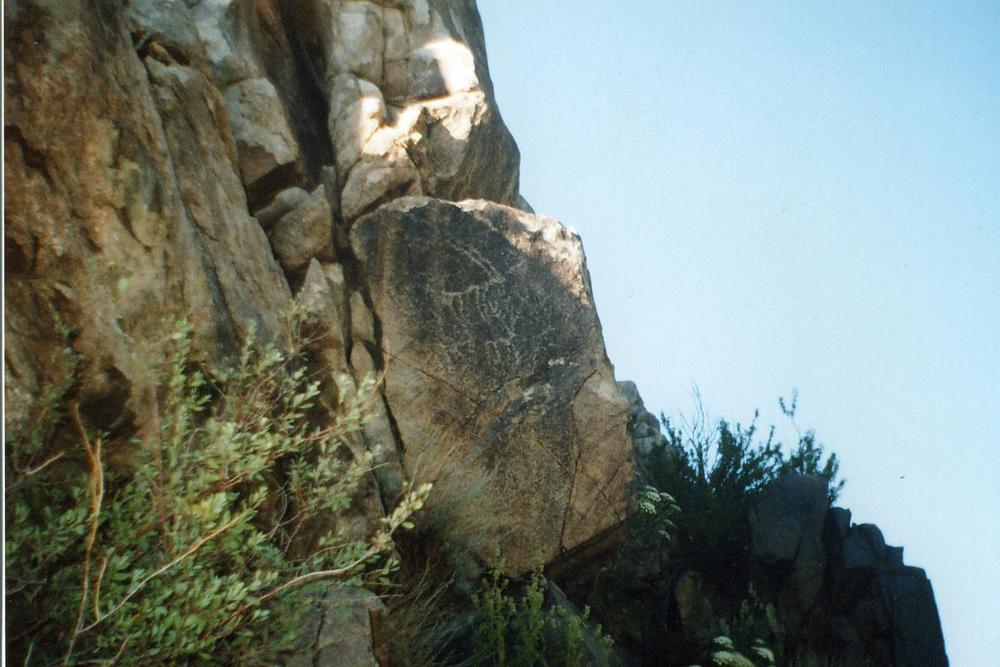
Taskesken’s petroglyphs spread at the foot of the ridge Tarbagatai (near s.Uch-Bulak) in three directions.
1. South-east direction
2. The central direction
3. North-easterly direction
1. South-easterly direction
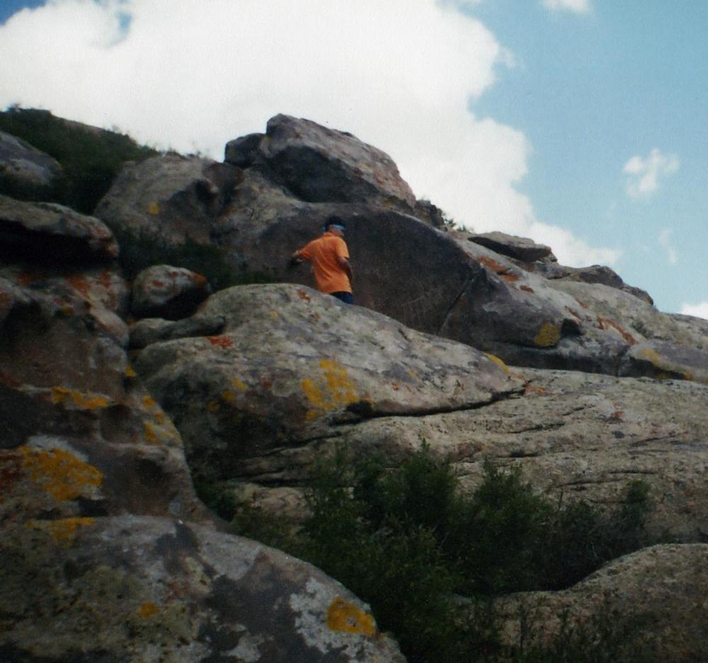
Here, the petroglyphs are located mainly in the high hills. We found only two kinds of stone figures. The site was chosen perfectly. To get to the pictures every chloveku easy. The stones were to draw a carefully prepared. Surprisingly, we found only a few of the petroglyphs.
2. Central direction.
On this site are concentrated several types of stone figures. The stone figures were probably the main purpose of the ethnonym "Taskesken" which translated means valley stone rezb (blocks).
3. North-easterly direction
We thought this part was like the gates to visit the place. On the way we came to an unknown letter "Һ" carved in stone separately. Images are stored well. Some of them are heavily exposed to weathering.
STUDIES IN THE WORLD PETROGLYPHS
| According to Internet resources, you can get acquainted with the situation and the current state of research in this field. |
.
On the Internet (http://nordictravel.ru/rus/petroglyphs.html) we drew attention to the similarity of some elements of the technology and processing of stone images of ancient people. The painting depicts a stone figure (White Sea petroglyphs, Onega Sea Russia) where the ancient artist tells about the life of animals in the imagination of the six thousand years sushestvuyuschii ago [34]. Below we see the same picture that was discovered in Taskeskenom area where technology figures indicate the origin of the petroglyphs in spite of the time years. The so-called "newspaper rock" (Utah, USA), which is far from Taskesken although in the end have an amazing relationship
| Some of the petroglyphs have an amazing spiritual and mythological connection with the mysteries of nature, while actually proving a stone image. These include Buddiskie drawings, Shaitan-stone and other monuments of the past. http://ru.wikipedia.org/wiki |
CONCLUSION AND EXPECTED RESULTS
1. Make a proposal to the Scientific Council of the Institute of Archaeology im.A.Margulan for inclusion in the list of the Archaeological map of Kazakhstan on materials Taskesken petroglyphs.
2. Develop a program tourist route oasis "Karakol-Urzhar."
3. Propose the inclusion of materials Taskesken petroglyphs in school and university textbooks, electronic textbooks and items.
4. Develop a project-proposal Taskesken petroglyphs on changes and amendments to the Law of the Republic of Kazakhstan "On Specially Protected Areas and natural areas in the Republic of Kazakhstan."
5. Develop a model of phase-preserving area Taskesken petroglyphs.
6. Make a proposal to UNESCO, the World Tourism Organization, the Government of the RK, Akim of East Kazakhstan region and Urzhar district of enrollment in the list of architectural monuments of ancient culture and tourism itinerary of stone figures Taskesken.
7. Infrastructure development and construction of hotel and tourism in the area with. Ush-Bulak and adjacent territory with a view to implementing a comprehensive plan project oasis "Urzhar-Karakol."
8. The Plan and other projects of architectural oasis with Urzhar Akim district.
9. Conducting on-site Taskesken petroglyphs of the International Scientific Conference and Symposium "Stone figures and their geographical and continental distribution in the world."
10. Organization of excursions, tourism and regional studies, research and other activities involving government, non-governmental organizations, educational institutions and international public funds for wider engagement and campaigning rock drawings.
11. Creating a Web Site "Petroglyphs Taskesken."
12. The Organization of Local ecotourism expeditions pupils of Kazakhstan with the participation of members of the Republican Children's Organization "Atameken", "Zhұldyz" and "Jas Ulan."
13. Release of research, teaching aids and books, abstracts and articles, photos, videos, electronic books, television broadcasting scientific and educational programs on Taskesken petroglyphs.
14. Develop a draft resolution (techno-economic characteristics, the improvement of social and cultural infrastructure) of the Government of the Republic of Kazakhstan "On the tourist and archaeological complex Taskesken."
15. The organization of archaeological expeditions, exhibitions, public cultural, scientific, methodological and educational, tourism and regional studies, and other events
GLOSSARY
- История Казахской ССР с древнейших времен до наших дней, А, 1979
- Ғ. Ақпанбек., - Қазақтардың дүниетанымы., - А, Қазақ университеті,. 1993, 53 бет.
- Қожаев Б., - Таңбалы тастар. (Таскескен өңіріндегі тасқа салынған суреттер мен таңбалар), «Мәдениет және тұрмыс», 1-1994, 14 бет.
- История Казахстана (с древнейших времен до наших дней). П/р М.К.Козыбаева,А:Дәуiр,1993,с. 416
- Қазақ Совет энциклопедиясы, А:ҚСЭ, 1975, 640 бет
- Бейсенова Ә.С., Кәрпеков К.,- Қазақстанның физикалық географиясы,А:Атамұра,1994, 274 бет
- Черников С.С.,- Поселение эпохи бронзы в Северном Казахстане.-КСИИМК,А:1954, вып.53
- Чалая Л.А.,- Озерные стоянки Павлодарской области. Пеньки 1,2.- В кн: Поиски и раскопки в Казахстане,А:1972 с.251
- Грязнов М.П.,- Северный Казахстан в эпоху ранних кочевников.-КСИИМК,А:1956, вып.61
- Марғұлан Ә.Х.,- Древняя культура центрального Казахстана,А:1966, с.282
- Зайберт В.Ф.,- Атбасарская культура, Екатеринбург,1992,с.251
- Қазақстан тарихы (көне заманнан бүгінге дейін). Төрт томдық.Ітом.-А:Атамұра,1996,-544 бет.
- Зайберт В.Ф.,- Ботай қонысының тарихи-мәдени маңызы // халықаралық «Сейтен тағылымдары» хылыми-практикалық конференциясы,Көкшетау 4-5 маусым, 2005 жыл, 258 бет
- Бойс М.,- Зороастрийцы. Верования и обычаи,М:1987, 256 с.
- Қазақстан. Ұлттық энциклопедия / бас ред.Ә.Нысанбаев.-А:ҚЭ Бас редакциясы, 1998.-720 бет.
- Кляшторный С.Г., Султанов Т.И.,- Казахстан: летопись трех тысячелетий,А:Рауан, 1992, с.374
- Ежелгі Қазақстан: Қазақстан балалар энциклопедиясы,А.Аруна,2002, 224 б.илл.
- Тимошинов В.,- Культурология:Казахстан-Евразия-Восток-Запад: Учеб.пособие.-А:Ниса,1997,336 с.
- История древнего мира: Учебник для 6кл.сред.шк //А.А.Вигасин,Г.И.Годер, И.С.Свенцицкая.-М:Просвещение,1993.-271 с.,ил.-
20. Қазақстан. Ұлттық энциклопедия // Бас ред. Б.Аяған.- А: ҚЭ, 2003.- 720 бет
21. Казахская ССР: Кр.энциклопедия в 4-х т. // Гл. Ред. Р.Н.Нургалиев, Т.,2608 стр., А., 1988.
22. Самашев З.С., Наскальные изображения Верхнего Прииртышья, А:1992
23. Археологические памятники в зоне затопления Шульбинской ГЭС.-А:1987
24. Таймагамбетов Ж.К., Древнейшая стоянка человека в Восточном Казахстане.- Маргулановские чтения. Петропавл, 1992
25. Шнитников А.В., Изменчивость общей увлажненности материков Северного полушария. // Записки Географического общества СССР, т 16, М-Л:1957
26. Марьяшев А.Н., Рогожинский А.Е., Наскальные изображения в горах Ешки-Ольмес, А,1991
27. Новоженов В.А. Наскальные изображения повозок Средней и Центральной Азии (К проблеме миграции населения степной Евразии в эпоху энеолита и бронзы)А,1994.
28. Черников С.С., Восточный Казахстан в эпоху бронзы.МИА, 1960. №88
29. Нифонтова Л.К., Андроновское погребение в Абаевском районе Семипалатинской области. «Из. АН Каз ССР», 1949, вып.2
30. Арсланова Ф.Х., Памятники андроновской культуры из Восточно-Казахстанской области
31. Ежелгі Қазақстан: Қазақстан балалар энциклопедиясы:А.,Аруна, 2002, 224 бет.
32. Сюань-Цзян. Исторические записки, Пекин, 1970
33. http://en.wikipedia.org/wiki/History_of_Kazakhstan
34. http://nordictravel.ru/rus/petroglyphs.html